
A history of Priory Stream, Priory water, and the many culverts of Hastings – plus the storm tunnel and its workings (and associated interesting facts)
History underground
Hastings and history go hand-in-hand – but whilst Harold and his ill-fated battle are the main thing that comes to mind (along with the town being the birthplace of TV), there is some fascinating stuff going on underground in the sewers and culverts that carry water from the hills to the sea.
We also discovered that this also worked in reverse for a few decades (have you heard od Hastings ‘third taps’?)… as well as discovering the name of the rather famous civil engineer who designed our Victorian sewers, a fun fact about how German military technology was recycled to help power the transport of Hastings’ poo, and also how that lumpy effluent had earlier been dried out and shipped up to London to feed the roses of the affluent – more of that later, including a short mention of George ‘Tom’ Harmer, who dedicated his life to keeping the rain at bay by controlling water levels at Buckshole Reservoir and gave his name to Harmer’s Reservoir.

The Priory Stream culvert in all its different guises
If you have heard of the Priory Stream culvert you may be surprised to know we have had about four distinct different culverts over the centuries.
A river ran through Hastings
Hastings once had a navigable river running inland from it’s mouth to the west of the castle cliffs (where the town centre now lies).
Due to changes in the local geology, this river gradually reduced to a stream, which meandered down the stretch we now know as Queen’s Road, before ending in a boggy marshland that was known as ‘Priory Water’.
This map shows the path of the old stream in black, with some of the original roads in yellow. The blue line is the current route of the stream as it flows through a 2m wide culvert that runs beneath the streets to exit on the beach, opposite the Carlisle Pub.

1700s – When Hastings had a real river
There are no Instagram posts unfortunately, but we do have several maps from as late as the 1700s that clearly show a fairly wide river.
And a survey carried out towards the end of the 18th Century indicated the mouth of the estuary was approximately 30m wide.

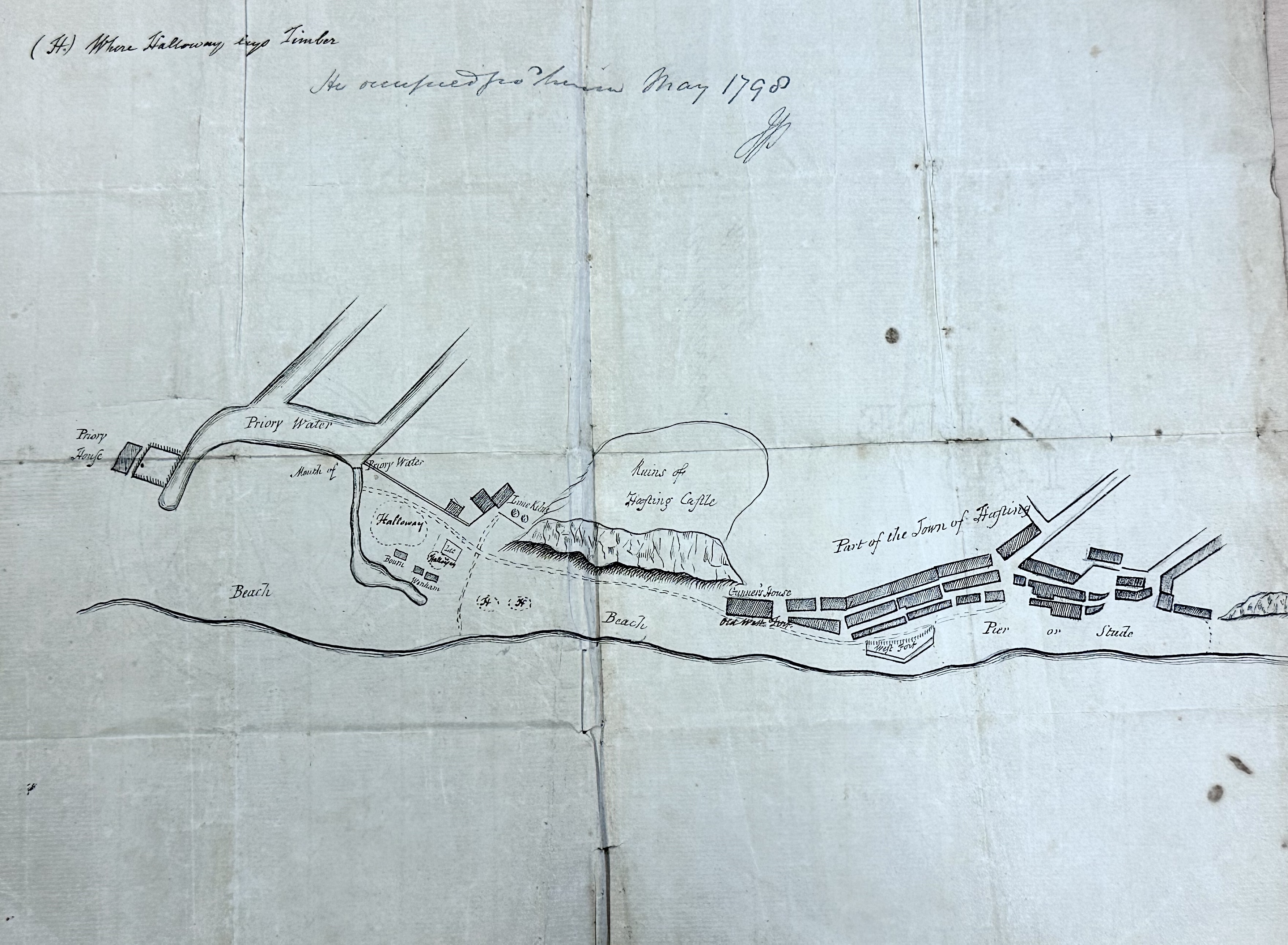
1798 and all that…
As the 18th Century drew to a close this map of the area shows how the build-up of shingle from the beach and silt from the river had turned the river into more of a marshy lagoon – Priory Water.
1816: An early sketch of the town centre
Here we can see what the area looked like in 1816

1830s: The America Ground is born…
You can read all about the America Ground in plenty of other places (some is true, some urban myth – your best bet is the book by Steve Peak) so we won’t bore you with that here. But this map from 1830 shows how the shingled land to the west of the Priory water had become occupied and built upon, with a bridge now sitting over the stream. Interestingly, and something still unclear, is how there appears to be a tributary feeding into the Priory Water from the west. The green area is the embankment dating from 1580, which was the first stage of a failed attempt to create a new harbour.

Let’s drain the marsh – 1839, and we get our first culvert
“The work of laying down a culvert for carrying the water from the brooks into the sea was completed on the 6th of April, Mr. Jonathan Reed’s contract for the same having been accepted on the 29th of October, 1838.“
BRETT
Back in those days plans for major engineering works were a little sketchier than today’s mammoth documents… so this feat of engineering to drain the marsh and create some solid land south of the old bridge was not exactly down to the milimetre – but it would seem it did the job.

Hastings as it looked in 1840

Culvert Number 2 – 1842
A few years after that first culvert project was completed, and on the assumption the marshy lands had been drained down, it seems it was time to reclaim the land between the old bridge location and the sea.
This plan from 1842 shows the proposed second stage culvert running under what is now Harold Place.
This would have allowed for the removal of the bridge by filling in the section of open stream between there and the sea wall.


1849: The Valley is cut in two – and culverts numbers three and four
1849 saw a new railway embankment built across the Priory Valley, and this overlay map (courtesy of Leigh Kennedy using an overlay of Cant’s 1855 map) shows how the stream divided to go into two new culverts beneath it via two routes, one roughly where the bridge now stands, and the other around the location of the pedestrian foot tunnel. The black sections are culverts and bridges.
It is interesting that there seem to be three springs leading from Queens Road to the stream, and it can be seen from this that the final culverted section at this time still ran from the Town Hall location down under Harold Place.

1859 original map
This contemporary (although later annotated) map again shows the estimated route of the open stream at this time.

1879: Penstocks for flooding the park?

This excerpt from a council report (1879 – courtesy of Leigh Kennedy) indicates how important the authorities saw it that the culverted stream be kept clear of blockages…
It also talks of plans to introduce two penstocks to the south of the park to use the area as a reservoir during high rainfall and high tides to reduce flooding in the town centre.
Whether these were actually put in place is unclear.
The rest of the report (below) does state that several properties would possibly continue to experience cellar flooding at some high tides.
“The committee traced frequent obstructions in the old sewer to the effect of the suction pipe and pump in connection with the salt water engine in the Authority’s stoneyard, at Queens Road, being placed in that sewer, and they accordingly suggested that (as other works are in course of construction for supplying salt water for road purposes), these should be removed immediately. This suggestion, having received the sanction of the Authority in Committee, has been carried into effect. In order to prevent drift wood and other things getting into and obstructing the sewer, the committee have had iron bars placed across each of the culverts in the St Andrews Gardens.
“The deputation, which waited upon the Committee on the 17th ultimo, suggested the advidability of placing penstocks on the culverts at St Andrews Gardens, so as to keep the water back their as soon as possible. The committee therefore recommended that, as an auxilliary to the works herinafter proposed, two new penstocks be purchased and fixed there. They are, however, of the opinion that if these works are carried out, these auxillary means will only need to be put into operation in the extreme case of a high tide and heavy rainfall occurring at the same time.”

The present course of the Mount Pleasant and Elphinstone Road sewer is through the archway, along the St Andrew’s Road to the junction of that road with Waterworks Road, and then along the latter road to where it meets the sewer from the gardens, which runs undr the railway embankment. The committee are of the opinion that the former sewer should be directly connected with the sewer in the gardens, and, therefore, recommended that a new connecting sewer, fifty yards in length, be constructed.
In consequence of the Gas Company’s large sewer (7ft 2in by 5ft 4in) the committee are of the opinion that the portions of the flood water sewer between the old Ash Yard and the north end of the company’s property and the south and of those premises and the north end of Mann Street should be enlarged two feet to make the dimensions 6ft by 4ft.
In the portion of the sewer which runs though the Gas Company’s premises, and which was put in by the company, they have constructed a species of dam for the purpose of collecting water for use in the works. Although the company do not consider this is, at the present time, the free flow of the flood water down to the sewer, owing to the small capacity of the Mann Street sewer referred to hereafter, they suggest that if tyhe works recommended by them be carried out, the Gas Company be asked to take into consideration the advisability of removing such dam entirely, and obtaining a supply of water for their purposes in some other way.
Through the entire length of Mann Street there is an old 3ft 6in sewer originally put in by the owners of the Cornwallis Estate. Upon examination a portion of this sewer was fond to have subsided by by about 18in, owing it is supposed to the treacherous state of the ground on which it was constructed, thus, to some extent, retarding the flow of the water. As the sewer runs under houses and buildings there woukd be by the way of enlarging or otherwise dealing with it, and the committee therefore recommend that a new duplicate 4ft 6in sewer, 200 yards in length, be constructed there, and connected with that recentluy constructed in the recreation ground.
The committee are of the opinion that the 7ft sewer in Station Road, with which both the valley sewers are connected, is of sufficient capacity to carry away all of the water brought down by those sewers. In order however, to facilitate the more speedy discharge of the immense volume of water brought down, the committee recommend that a new outlet (4ft 6in brickwork and 4ft iron pipe) be constructed, in accordance with a plan prepared by the Surveyor, for the purpose, between the main sewer near the Albert memoral and the sea.
In conclusion the Committee wish it to be understood that the additional works recommended by them may not always provide against the flooding of the six or eight cellars or basements that are below the level of high water mark at spring high tides in the case of a high tide and heavy rainfall occurring simultaneously.
The park and embankment, 1866

A certain Mr Bazalgette…1867 sewer plans
Not actually relevant to the history of the Priory stream and its various culverts, but in carrying out this research it was fascinating to hold an original letter from Joseph Bazelgette, who was commissioned in 1867 to oversee plans for the town’s new sewer system.

1873 Ordanance Survey map
Here’s a detailed map of the town from 1873 – what seems clear at this point in history is that the Priory Stream was an integral part of the combined sewer system – and this seems to have been the case until the mid-20th Century.

A letter to the council – 1879
This letter describes a few suspected issues with the culvert and sewer system – and also the proposals to introduce penstocks in the park.
At this date it seems the outflow is still at Harold Place (Queens Hotel), but there is mention of a second culvert under the cricket pitch…although we have yet to find any maps of either of these.
(Thanks again to Leigh Kennedy for this)

Another American connection – or a different acronym?
A few people have questions this plan relating to a poposed culvert construction dated 1884. The seal is almost certainly that of Hastings Council, but what does ‘U.S.A.’ mean in this context? Underground Sewer Anyone?
Well no… as it happens, our friend Leigh Kennedy tells us it was the ‘Urban Sanitory Authority‘ back in those days.
This could be the plan for the main culvert inlet we now see at the entrance to the park, which we know runs to the west before turning south under the railway just alongside the pedestrian tunnel.

Buckshole reservoir – surface water drainage control (and that ‘third tap’ we mentioned…
Whilst well upstream of the culvert, Buckshole Reservoir had a big part to play in holding back rainfall from the top of the catchment area, and in the late years of the 19th Century, after ceasing to be used for the supply of drinking water for the town, this was its only function other than as an ‘ornamental feature’

Skip forward to 1899 – and culvert number FIVE
This detailed ordanance survey map from 1899 shows that the stream now seems to have been diverted to run beneath Queens Road where it is marked with a dotted line and the key ‘C.C.Sewer’
Again, Leigh tells us this stands for ‘Covered and Culverted Sewer’.
Importantly, at this time it seems as if the culverted stream ran into the same network as all of the town’s surface water and sewage, and this will have resulted in significant issues because of the volume of water that system would have been faced with during high rainfall.

The following sections show the outflow through Harold Place. The top section takes a tun out of Stonefield Road.


Sewage straight to the sea
This 1900 map overlay gives a clearer picture of how our waste water used to just drain directly across the beach.

The Harold Place outflow and ongoing town centre flooding issues
A plan from 1976 showing the relative levels of the various gullies in Midde Street and Station Road may give some clue as to why extreme high tides could have brought flooding into the town centre.
A high spring tide could potentially be a metre or so above the AOD levels of some of these gullies.
However, this outflow was capped off some years ago, so recent flood events should never be impacted by tides in the way that used to happen.

Sluice gate mystery
In 1899 we also see this sluice marked clearly on the map in the yard off Waterworks Road – it’s purpose (and whether it still exists underground) is currently unknown, so if you have any ideas do get in touch.

How a German U-boat helped pump Hastings sewage…
The story of how a German U-boat washed up on Hastings beach after WWI is reasonably well known.
What is less well-known is that we pinched the engine to provide the town’s first pumped sewage system!

1937 – and the ‘concrete king’ Sidney Little, makes it culvert number SIX for Hastings…
Although we still can’t track down detailed plans, we found this cutting from the local paper in December 1937 which explains how Sidney Little diverted the lower end of the Queens Road culvert under Wellington Square.


What sluices?
This reference to a sluice system is an interesting one, and we are looking for more details to understand what it relates to and whether it is still in operation…

Two years later, and it’s number SEVEN
Once again, we are looking for more details, but this article on the history of Hastings sewers indicates that this may have been the point at which the route of the culvert was moved once more to run along the railway embankment, down along South Terrace, and connect to the tunnel beneath Wellington Square.

The final section – Pelham outflow
It’s not certain when the final pipe out onto the beach was installed, but at the edge of the beach next to the road there is a large square chamber with a tidal non-return valve (think an eight-tonne catflap).
Water from the culvert goes into this chamber before making it’s final charge to the sea down a 1.2m pipe that is the one which broke its back back in 2017, and has subsequently been repaired.

The Native Guano Company
We mentioned at the start an enterprise set up to sell Hastings’ own-brand fertilizer to affluent Londoners in the late 19th Century.
Well here’s the base of operations at Rock a Nor in 1870…
It’s certain that the ‘Native Guano’ brand name would have been a better sales pitch than the name of the local Hastings firm who entered into a partnership to deliver this particular product.
Our forefathers had adopted the more straightforward name of ‘Hastings Sewage Manure Company‘…
There is a good feature on this here.

George ‘Tom’ Harmer, Buckshole reservoir attendant, 1851-1901
‘Tom’ used to maintain levels at the reservoir so that during heavy rain there was capacity to hold back floodwater.
Maybe we need an new ‘Tom’?


The Hastings Storm Tunnel
What is the tunnel for and does it work?
Imagine you have left the taps running on your bath.
As the water nears the top, it doesn’t just keep rising…because the overflow outlet sends it to the drain before it floods your bathroom.
Of course if you have the tap on full blast this might only slow the inevitable – because the overflow can only allow so much through and the speed of the water coming in might be faster than what goes out.
Now imagine Hastings is a giant bath, and the rainfall is the tap.
It’s a bit more complex of course, because some of the rain goes into natural streams and runs (through our culverts) out to sea. The rest either lands on soil and soaks into the ground, or it hits hard surfaces like roads and roofs and ends up in the sewers (which are a combination of rainwater and waste water).
So let’s reimagine our bath.
Now it doesn’t have just one plughole, it has two.
One (our culverted stream) is open all the time, and water just goes straight through it to the sea.
The other (our sewer system) is also open all the time – but it is restricted by the speed at which waste water can be treated and cleaned before also finding its way back to the sea.
On ‘normal’ days when we’ve not had much rain (the analogy here is standing in the bath to have a shower, rather than running the taps for a full bath) all of the water in the tub simply flows away as fast as it come in.
Now, however, imagine that we have a potentially really powerful water supply (really heavy rain!) in order to run the taps enough to fill up the bath faster than water drains away. And also imagine that on the majority of days when you run a bath, you only need to turn those taps on to half their maximum in order to bring the level up to where you want it.
Of course, you might still get a phone call to distract you at the wrong moment, so there is still an overflow pipe to stave off disaster.
In the ‘real world’ this overflow is dealing with the mixed sewage, so we don’t want our bathwater going into the drain that goes straight to the sea. However, because the main plughole is already pushing as much water through our treatment facility as it can cope with we need another solution – and that’s where the storm tunnel comes in.
It’s basically a big bottle sitting underneath our bath, and it acts like a reservoir to hold water from the overflow outlet until bathtime is over and it can be fed into the treatment pipe.
Our real-world tunnel/reservoir actually has several overflows running into it – one up towards Ore, and another in the town centre – but you get the picture.
But what happens if leave the taps running for a lot longer than just the space of a phone call because we’ve forgotten about our bath plans?
Water can’t get out of the plugholes any faster, and now the capacity of the overflow bottle (the storm tunnel) is reaching its maximum – and if this happens, no more water can get into it through the second bath overflow.
Luckily the bottle also has an overflow in this situation – and although it’s not a perfect solution it does normally stop any damage to our bathroom floor. The reason it’s not perfect is that the overflow is direct to the sea (the outflow at Warrior Square in fron of Goat Ledge)… which isn’t ideal, but it’s better than dirty water flooding the house (or the town).
Unfortunately, as we have seen twice in 2023, there are times when the bath taps get turned on so hard and are left on so long that none of these safeguards can cope…and in October we saw the second flood in ten months following huge rainfalls.
Now the thing is, there are a lot of variables in a real-world situation, and all of them influence how fast water actually gets through the system (and what course it takes).
Since the storm tunnel was created we’ve had lots of rainfall events in Hastings that before the tunnel was put in place might have been expected to flood the town – but it has worked, and kept us dry.
What changed in 2023?
Well, an ESCC report points to a new manhole that had been dug in South Terrace to allow a new access point to the culverted streams.
This essentaially created a temporary ‘crossed wire’ between the streams and the sewer system.
The culverted streams normally flow quite happily to the sea without any problems. But once the ‘taps’ are turned on full it seems that even if the last part to the sea is clear of shingle (as it was in October 2023), the water still backs up because it can’t get out through the final section of pipe as fast as it is coming in at the top.
Before the manhole was dug, this pressurised back-up of water went right to the top of the culvert, and led to flooding in the park.
However, this pressure was enough to force the South Terrace manhole to blow open, creating the ‘crossed wire’ that saw even more water flowing into the town centre sewers, and with this extra burden, the capacity of the various overflows simply couldn’t cope – leading to the floods we saw devestating shops and homes.
What next?
Well, the manhole has been closed, so for the time being that ought to keep the stream waters seperate from the sewers.
However, there is still the risk that the pressure in the system (if we get another similar event) could burst out through the road surface.
So there are a few things to consider:
- Can we speed up the flow of water out of the culvert to the sea – possibly by adding a second pipe across the beach, as the main section is 2m and the beach pipe only 1.2m?
- Can we hold back water during intense heavty rain – either by contolled use of Buckshole reservoir, or putting in a valve to the culvert and allowing the bottom end of the park to flood more deeply?
- Can we consider the ‘unthinkable’ and on rare instances open more overflows direct to the sea?
Many people say that Hastings has always flooded and so will always flood, but we believe this doesn’t have to be true.

